SAARNAKI NATURE TRAIL
Islets are just wonderful places to be, especially Saarnaki. But if you have a little time and a deeper interest in the island's nature, you could take a walk on the Saarnaki nature trail. You should set aside about an hour for this. However, if you want to enjoy the diverse landscapes longer and perhaps look a little into your own soul, it will certainly take more time.
The length of the trail is about 1.7 km.
On the trail, you will find 14 information boards explaining plants, animals, landscapes, and human activities.
Near the farm buildings, you will find an information board about the human settlement and buildings of the islet.
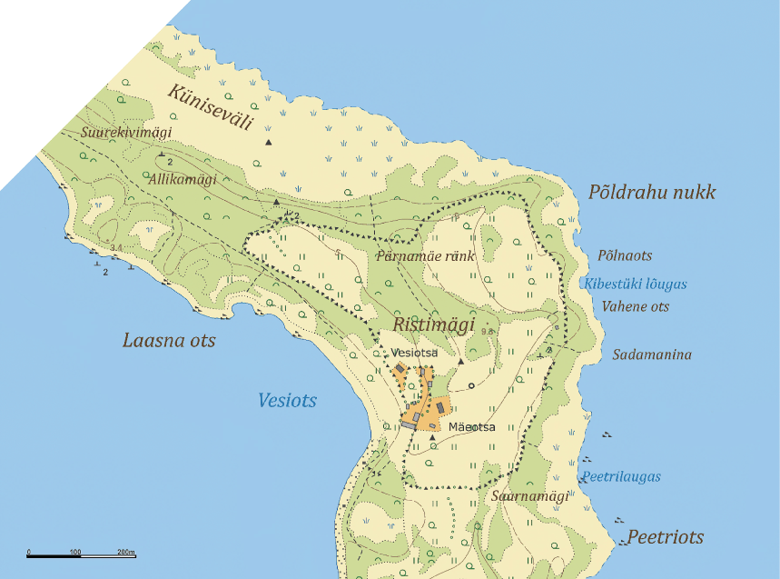
Nature trail route map (approx. 1.7 km) • Click a marker to view stop
Trail Points
-
1.
First, we will get to know the "true inhabitants" of the islet, the stoat and the grass snake, which can occasionally be seen around the houses.
-
2.
Alvar juniper woodlands are semi-natural areas characteristic of the islet. The vegetation here is relatively stunted, but rich in species and colors.
-
3.
Several orchids grow in the moister juniper woodlands. There are four species of orchids in the observed area. An interesting plant is the common butterwort with its purple flowers.
-
4.
We reach the “world of sheep”, for which we have to use a stile to help us over the rail fence. From early spring to late autumn, sheep do landscape maintenance work here.
-
5.
Larger amounts of surface water stay longer in the depressions between the coastal ridges, forming moist alvar meadows with their characteristic vegetation.
-
6.
A point of land with large stones, called Laasna ots. Wind, sea waves, and ice all do their destructive work here.
-
7.
Pärnamäeränk. An accumulation of erratic boulders with an ancient linden grove is one of the most impressive places on the trail. This is a 6–7 m high coastal escarpment.
-
8.
Coastal meadow called Küniseväli. An area between land and sea that is occasionally flooded by the sea. A habitat and feeding ground for migrating and nesting waders.
-
9.
The juniper is the symbol of the islet. They grow almost everywhere and thus form a major part of the beauty of the island's landscapes.
-
10.
Ascending higher from Küniseväli along the Winter Road, we return to the “world of people”. The more open area located here was and still is a hayfield and bears the name Altmäekare. The vegetation is rich in species and “flowery” in summer.
-
11.
We have come full circle back to the buildings and will stop briefly at the windmill to get acquainted with its construction and see what lands and islands are visible across the sea.
-
12.
An overview of the island's history of settlement and buildings. Saarnaki was one of the first of the Väinameri islets on which human settlement was documented in writing.
-
13.
Wrack bed. On Saarnaki, the main part of the plant accumulations on the shore consists of eelgrass, a flowering plant with long green leaves, rather than wrack, which belongs to the brown algae. Thus, it could also simply be called a mud ridge.
-
14.
Pond. The pond on Saarnaki islet was formerly used primarily for watering livestock, obtaining household water, and fetching sauna water. It was also used temporarily for storing live fish in small cage-wells for personal use.
Saarnaki islet
Saarnaki is one of the largest and oldest islets in the waters of Hiiumaa. The higher parts of the islet rose from the sea about 2500 years ago. Currently, the area of Saarnaki is 136 ha and the highest elevation above sea level is 8.9 m. The islet is curved and elongated in shape, its greatest extent from north to south is 3.3 km and from east to west 0.9 km, the length of the coastline is 9.6 km.
Saarnaki, like most of the islets of southeastern Hiiumaa, consists mainly of terminal moraine material, i.e., rocks carried to these areas by glaciers during the Ice Age. The western coast has shingle coastal ridges and a little sandy beach, the eastern coast is gentler and vegetated. The abundance of erratic boulders and the presence of a zone of former sea coastal ridges are characteristic.
Flora and fauna
At least 161 species of lichens and 118 species of mosses, as well as over 380 species of vascular plants, grow on Saarnaki. Among the latter, the most notable are the small scabious and several orchids, such as the fly orchid and the early marsh-orchid. Of the amphibians, the moor frog lives here. Formerly also the natterjack toad, which they attempted to reintroduce here in 2004–2008, but it could not adapt, no breeding was observed, and it is currently absent from the islet. Of the reptiles, the grass snake lives on the islet. 76 species of breeding birds are known from Saarnaki, the most numerous of which are the lesser whitethroat and the chaffinch. There are 6 species of small mammals, including the northern bat and the Daubenton's bat. The yellow-necked mouse is numerous around the buildings, and is prey for the stoats living in the stone walls there. Foxes and raccoon dogs have a significant impact on the abundance of ground-nesting birds and hares. Occasionally, wild boars and moose also swim to the islets. A total of 35 protected plant and animal species live permanently or occasionally on Saarnaki.
The value of the islet is its mosaic nature. In a relatively small area, the landscape alternates, and with it the communities. Alvar juniper woodlands predominate on Saarnaki, but the old linden grove on Pärnamäeränk, alvar forests, various coastal communities (on coastal meadows and ridges), mown grasslands, and patches of swampy meadows are also important here.
Nature Reserve
The islet was placed under protection in 1968 as part of a botanical-zoological nature reserve, which was transformed into a landscape reserve in 1971. To preserve the semi-natural communities, former cultivated lands (24 ha) are mown and sheep are grazed (84 ha). The Hiiumaa Islets Landscape Reserve is an Important Bird Area (IBA), a wetland of international importance (Ramsar site) together with Käina Bay, and part of the Natura 2000 Väinameri bird and nature conservation area.
Visiting the islet. The lands and buildings of the islet are predominantly privately owned. Overnight stays on the islet must be arranged with the landowner or property manager.
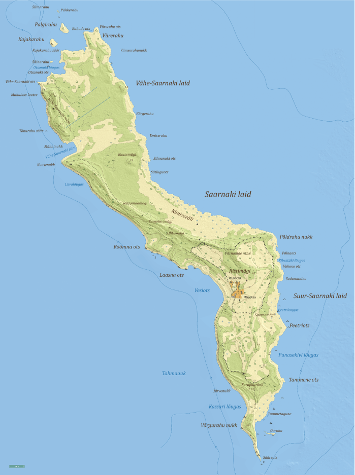
Map of Saarnaki Islet
- Trail compiler and texts: T. Leito (OÜ Kivirullija) 2004, updated 2026
-
Poster design and production:
T. Kaljuste (
 OÜ Folialis) 2004, updated 2026
-
Project "Renewed Saarnaki Nature Trail" implementer:
 MTÜ Saarnaki Laid, 2026
